
Rivers, Streams and Strines
Question: When is a river not a river? Answer: when it’s on the Weald Moors, of course! For centuries, natural waterways in the east Shropshire moorlands have been known, in the local vernacular, as ‘strines’ — an ancient colloquialism that has long since passed into popular terminology. Yet, where matters of identity are concerned, for the River Strine and its similarly named tributaries, the sense of puzzlement runs much deeper than that…
River, Stream or Strine? In the UK, rivers are generally defined as waters with a channel width of more than 8.25 metres. Nationally, there are at least 90 000 kilometres of waterway that meet this very specific definition but, even by the most wildly optimistic of calculations, it would be quite a stretch to include any of the Weald Moors slender watercourses among them. So, while the River Strine (once known as Newport Strine) may be the principal moorlands waterway, in terms of girth at least, the second part of its name (meaning ‘stream’) is far more accurate than the first!

Why are they important? While the Weald Moors may lack a river in the strictest sense, for the many plants, animals and insects that rely on running water, the area’s gently flowing lowland streams perform much the same function. Yet, the feeling that all is not quite as it seems is felt equally strongly here, too. While rivers and streams bring a degree of permanence to the landscape, they are effectively ever-changing habitats sculpted by the interactions of water, sediment and the plant life within and upon their shifting banks. Indeed, it’s precisely this quality that provides such a wide variety of aquatic life with the different conditions it needs to survive throughout the year.
Land plants also play a key role in how much water reaches a river or a stream — hawthorn hedges, for example, may intercept as much as half of all the rainfall they receive. This helps illustrate yet another level of ambiguity because a river is much more than just the channel we see. Water movement below the rocks and gravels of its bed and upon the land over which it flows in times of flood all influence what life may be seen within it and, in turn, provide aquatic species with an opportunity to spread out into the wider landscape.
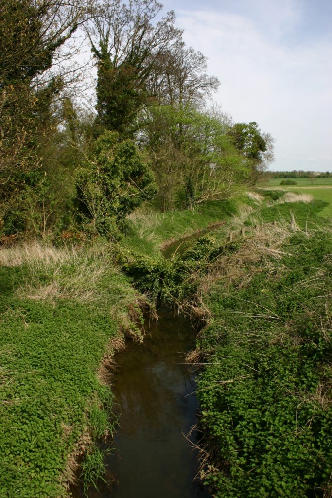
What To Look For: as a general rule of thumb, the natural watercourses on the Weald Moors run from east to west. Those flowing in a north-south direction belong, for the most part, to the elaborate Nineteenth Century system designed to create a ‘drainage run’ through the entire moorland landscape towards the River Tern. However, as part of that scheme, many of the area’s strines were also straightened, widened and embanked, robbing them of the naturally sinuous features so closely associated with good wildlife habitat. Nevertheless, the continued presence in the area of fish species associated with healthy conditions (such as Eel, Bullhead and Lamprey) says much for the continuing importance of the Weald Moors gently-flowing waterways to local wildlife.
Long stretches of water with plenty of submerged and emergent vegetation will often be the best places to begin searching because they provide shade, shelter and hunting opportunities for species at both ends of the food chain: from caddis and mayflies to kingfishers, otter and polecat. Tall sedges and reeds with stiff stems also help to bind sediment, while the presence of natural bankside vegetation will slow the progress of any pollutants into the water. This, perhaps, is the most illusory aspect of all surrounding the true identities of rivers and streams. They are sensitive to all activities taking place within their catchment and, no matter how good they look, their health will really be a reflection of the places they help drain.

On the Weald Moors: sadly, public access on the moorlands is such that there is really nowhere to experience a traditional river walk in the classic sense. Consequently, the best way to view the River Strine is from one of the many bridges that straddle its course as it crosses the moors. Crudgington Green, Rodway, The Wall and Adeney are all good locations to ponder the connection between waterway and landscape, each offering a subtly different perspective on the role of plants as the true engineers of rivers and streams. Continuing a now familiar theme, the River undergoes something of an identity crisis as it skirts Edgmond, where it becomes the Pipe Strine!
The situation is little better elsewhere and recourse to an OS Map will present its tributary, the Strine Brook, as something of an omnipresence, appearing in the south and west of the moors simultaneously! In this instance, things really were much better in the old days when the section crossing Tibberton Moor was known as Wall Strine (which can be followed for some of its length on the permissive paths around Wall Farm) and that bisecting Kynnersley and Preston as Sydney Strine. It can be viewed from the minor road between the two villages and is one of the few genuinely sinuous watercourses in the area. The natural contrast provided by smaller arteries like these, which often have different flow rates, temperature characteristics and sediment levels, can be hugely valuable in attracting a wide array of aquatic wildlife (they are important spawning grounds for several fish species, for instance) and are well worth exploring in their own right.
RELATED CONTENT:
Weald Moors Species: Emergent Grasses and Rushes
Weald Moors Species: Bullhead
Weald Moors Species: European Eel
Weald Moors Species: Northern Lamprey
Weald Moors Species: European Otter